Press release
Leading Satellite Imagery Provider for Remote Sensing and Earth Observation | SI Imaging Services
SI Imaging Services (SIIS)is a leading satellite imagery provider for remote sensing and earth observation. The SIIS has the exclusive worldwide marketing and sales representative of KOMPSAT series which is KOMPSAT-2, KOMPSAT-3 and KOMPSAT-5.SIIS contributes Remote Sensing and Earth Observation industries by providing very high resolution optical and SAR images through over 160 sales partners worldwide. Customers from industries as well as government are using geospatial information extracted from KOMPSAT imagery for their missions such as mapping, agriculture, disaster management, and so on.
SIIS KOMPSAT SERIES
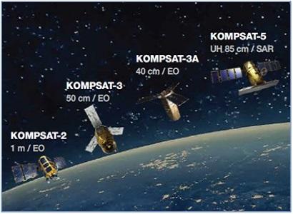
KOMPSAT-2 provides 1m resolution panchromatic and 4m resolution multispectral images.
Imaging performance: The system is equipped with a solid state recorder to record images not less than 1,000km long at the end of life. The satellite fulfills drift and jitter accuracy requirements. The maximum LOS (LOS) drift will be 0.005 deg/sec and the maximum LOS jitter will be 0.4 micro-radians over 4.7 milliseconds. The satellite can be rolled up to ±30 degrees off-nadir to pre-position the MSC swath.
KOMPSAT-3 provides 0.7m panchromatic and 2.8m resolution multispectral images.
KOMPSAT-5 is equipped with a synthetic aperture radar (SAR) payload, which will provide spotlight mode (1m), strip mode (3m) and scan SAR mode (20m) data.The KOMPSAT-5 system consists of space segment, ground segment, launch segment, and various external interfaces.
KOMPSAT-5 Imaging modes:
The KOMPSAT-5 can be acquired in three observation mode. Observation modes with one polarization selectable among HH, VV, HV, or VH
High Resolution mode: High-resolution mode collected over a small area by steering the radar beam slightly fore-to-aft during the collection period.
Standard mode: A medium-resolution mode collected over long, continuous swaths in which the beam is pointed broadside to the satellite track.
Wide Swath mode: A low-resolution mode that creates extra-wide swaths by collecting short segments at different ranges and then mosaicking them together.
If you are looking for KOMPSAT Series, you can find them at SI Imaging Services.
Click hereto contact SI Imaging Services.
View more: SI Imaging Services Leading Satellite Imagery Provider for Remote Sensing and Earth Observation
Korea
SI Imaging Services (SIIS)is a leading satellite imagery provider for remote sensing and earth observation.
This release was published on openPR.
Permanent link to this press release:
Copy
Please set a link in the press area of your homepage to this press release on openPR. openPR disclaims liability for any content contained in this release.
You can edit or delete your press release Leading Satellite Imagery Provider for Remote Sensing and Earth Observation | SI Imaging Services here
News-ID: 2882480 • Views: …
More Releases from SI Imaging Services

Worldwide Marketing and Sales Representative of the KOMPSAT Series | SI Imaging …
SI Imaging Services (SIIS) is the KOMPSAT series' global marketing company and sales representative in KOMPSAT-3, KOMPSAT-3A and KOMPSAT-5. SIIS contributes to the Remote Sensing and Earth Observation industries by providing very high resolution optical and SAR images through a global network of over 160 sales partners. Geospatial information extracted from KOMPSAT imagery is used by customers in industries and government for missions such as mapping, agriculture, disaster management, and…
More Releases for KOMPSAT
UAV Satellite Communication (SATCOM) Market Key Players Analysis - Honeywell Int …
InsightAce Analytic Pvt. Ltd. announces the release of a market assessment report on the "Global UAV Satellite Communication (SATCOM) Market Size, Share & Trends Analysis Report By Application (Marine Surveillance, Disaster Management, Surveying and Mapping, Industrial Inspection and Monitoring, Military ISR, Agriculture and Forestry, Civil Surveillance, and Cinematography), Drone Type (fixed wing and rotary wing), Frequency Band (Ku Band, Ka Band, X Band, C Band, S Band, L Band, Q…
UAV Satellite Communication (SATCOM) Market Growth and Restrain Factors Analysis …
InsightAce Analytic Pvt. Ltd. announces the release of a market assessment report on the "Global UAV Satellite Communication (SATCOM) Market Size, Share & Trends Analysis Report By Application (Marine Surveillance, Disaster Management, Surveying and Mapping, Industrial Inspection and Monitoring, Military ISR, Agriculture and Forestry, Civil Surveillance, and Cinematography), Drone Type (fixed wing and rotary wing), Frequency Band (Ku Band, Ka Band, X Band, C Band, S Band, L Band, Q…
UAV Satellite Communication (SATCOM) Market Study Analysis with Forecast to 2034
InsightAce Analytic Pvt. Ltd. announces the release of a market assessment report on the "Global UAV Satellite Communication (SATCOM) Market Size, Share & Trends Analysis Report By Application (Marine Surveillance, Disaster Management, Surveying and Mapping, Industrial Inspection and Monitoring, Military ISR, Agriculture and Forestry, Civil Surveillance, and Cinematography), Drone Type (fixed wing and rotary wing), Frequency Band (Ku Band, Ka Band, X Band, C Band, S Band, L Band, Q…
UAV Satellite Communication (SATCOM) Market Report- Expansive Coverage on the Pr …
InsightAce Analytic Pvt. Ltd. announces the release of a market assessment report on the "Global UAV Satellite Communication (SATCOM) Market Size, Share & Trends Analysis Report By Application (Marine Surveillance, Disaster Management, Surveying and Mapping, Industrial Inspection and Monitoring, Military ISR, Agriculture and Forestry, Civil Surveillance, and Cinematography), Drone Type (fixed wing and rotary wing), Frequency Band (Ku Band, Ka Band, X Band, C Band, S Band, L Band, Q…
KOMPSAT satellite Direct Receiving System (DRS) Service Provider in Korea | SI I …
SI Imaging Services (SIIS) is a KOMPSAT satellite imagery products DRS service provider in Korea.
KOMPSAT Satellite Imagery Products DRS is a part of the Korean government's space development program, which aims to provide high-resolution satellite imagery.
SIIS provides satellite imagery to customers who want to map a wide area, monitor large construction sites, understand urban planning and economic scale, or observe oil or gas facilities to obtain reserves.
In addition, the SAR…
Worldwide Marketing and Sales Representative of the KOMPSAT Series | SI Imaging …
SI Imaging Services (SIIS) is the KOMPSAT series' global marketing company and sales representative in KOMPSAT-3, KOMPSAT-3A and KOMPSAT-5. SIIS contributes to the Remote Sensing and Earth Observation industries by providing very high resolution optical and SAR images through a global network of over 160 sales partners. Geospatial information extracted from KOMPSAT imagery is used by customers in industries and government for missions such as mapping, agriculture, disaster management, and…
