Press release
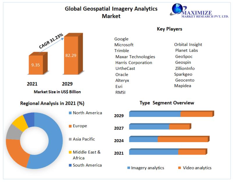
Geospatial Imagery Analytics Market to Reach USD 82.29 Bn by 2029, emerging at a CAGR of 31.23 percent and forecast 2022-2029
Geospatial Imagery Analytics Market
Our comprehensive report dives into the world of Geospatial Imagery Analytics, unraveling its significance in business intelligence and risk assessment. With approximately 80% of enterprises harnessing location data, businesses can leverage geospatial analytics to pinpoint customer locations, helping them make informed decisions regarding store locations and customer outreach.
Request a Free Sample Copy or View Report Summary:https://www.maximizemarketresearch.com/request-sample/25157
Geospatial Imagery Analytics Market Research Methodology:
Our research methodology employs a meticulous analysis of global and regional markets for geospatial imagery analytics. We identify key factors contributing to regional disparities in market growth, offering valuable insights for businesses seeking to harness the full potential of this technology.
What are Geospatial Imagery Analytics Market Dynamics:
Looking ahead, the global Geospatial Imagery Analytics Market is expected to surge to a value of US$ 82.29 billion by 2029, growing at an impressive CAGR of approximately 31.23% during the period from 2022 to 2029. This remarkable growth highlights the immense potential of geospatial imagery analytics in various industries.
To Gain More Insights Into The Market Analysis, Browse Summary Of The Research Report:https://www.maximizemarketresearch.com/market-report/global-geospatial-imagery-analytics-market/25157/
What is Geospatial Imagery Analytics Market Segmentation:
by Type
• Imagery analytics
• Video analytics
by Vertical
• Healthcare
• Government
• Defense and Security
• Environment Monitoring
• Engineering and Construction
• Agriculture
• Energy and Utilities
• Others
by Deployment Modes
• Cloud
• On-premises
by Collection Medium
• Geographic Information System (GIS)
• Satellites
• Unmanned Aerial Vehicles (UAVs)
• Others (helicopter, aircraft, helikites, kites, balloons, and airships)
Request a Free Sample Copy or View Report Summary:https://www.maximizemarketresearch.com/request-sample/25157
Who are Geospatial Imagery Analytics Market Key Players:
• Microsoft
• Trimble
• Maxar Technologies
• Harris Corporation
• UrtheCast
• Oracle
• Alteryx
• Esri
• RMSI
• Hexagon
• TomTom
• Orbital Insight
• Planet Labs
• GeoSpoc
• Geospin
• ZillionInfo
• Sparkgeo
• Geocento
• Mapidea
For any Queries Linked with the Report, Ask an Analyst@ :https://www.maximizemarketresearch.com/inquiry-before-buying/25157
Table of content for the Geospatial Imagery Analytics Market includes:
Geospatial Imagery Analytics Market : Research Methodology
Geospatial Imagery Analytics Market : Executive Summary
Market Overview and Definitions
Introduction to the Global Market
Summary
Key Findings
Recommendations for Investors
Recommendations for Market Leaders
Recommendations for New Market Entry
3. Geospatial Imagery Analytics Market : Competitive Analysis
MMR Competition Matrix
Market Structure by region
Competitive Benchmarking of Key Players
Consolidation in the Market
MandA by region
Key Developments by Companies
Market Drivers
Market Restraints
Market Opportunities
Market Challenges
Market Dynamics
PORTERS Five Forces Analysis
PESTLE
Regulatory Landscape by region
North America
Europe
Asia Pacific
Middle East and Africa
South America
COVID-19 Impact
4.Company Profile: Key players
Company Overview
Financial Overview
Global Presence
Capacity Portfolio
Business Strategy
Recent Developments
Geospatial Imagery Analytics Market Regional Insights:
Asia Pacific (APAC): The geospatial imagery analytics market in APAC is poised for remarkable growth, with an expected CAGR of 31.9% during the forecast period. This surge is propelled by the increasing number of internet users and the widespread adoption of connected devices. The region's thriving startup ecosystem and government investments in geospatial imagery technology further contribute to the robust growth of the APAC geospatial imagery analytics market.
China: In 2018, the Chinese government initiated its first comprehensive survey of geographical conditions, marking a significant step in environmental investigation and data collection. This comprehensive endeavor encompasses water, soil, and agriculture data, serving as a primary resource for policymaking. China is also actively investing in the development of a spaceborne airborne observation system, bolstering its national and global capabilities for responding to emergencies.
Request Free Sample Copy (To Understand the Complete Structure of this Report [Summary + TOC]) @ :https://www.maximizemarketresearch.com/request-sample/25157
Key Offerings:
Past Market Size and Competitive Landscape (2022 to 2029)
Past Pricing and price curve by region (2022 to 2029)
Market Size, Share, Size and Forecast by different segment | 2022-2029
Market Dynamics - Growth Drivers, Restraints, Opportunities, and Key Trends by region
Market Segmentation - A detailed analysis by growth and trend
Competitive Landscape - Profiles of selected key players by region from a strategic perspective
Competitive landscape - Market Leaders, Market Followers, Regional player
Competitive benchmarking of key players by region
PESTLE Analysis
PORTER's analysis
Value chain and supply chain analysis
Legal Aspects of business by region
Lucrative business opportunities with SWOT analysis
Recommendations
More Related Reports:
Global Orange Extract Market https://www.maximizemarketresearch.com/market-report/global-orange-extract-market/41079/
Global Tangerine Essential Oil Market https://www.maximizemarketresearch.com/market-report/global-tangerine-essential-oil-market/42365/
Contact Maximize Market Research:
MAXIMIZE MARKET RESEARCH PVT. LTD.
⮝ 444 West Lake Street, Floor 17,
Chicago, IL, 60606, USA.
✆ +1 800 507 4489
✆ +91 9607365656
🖂 mailto:sales@maximizemarketresearch.com
🌐 https://www.maximizemarketresearch.com
About Maximize Market Research:
Maximize Market Research is one of the fastest-growing market research and business consulting firms serving clients globally. Our revenue impact and focused growth-driven research initiatives make us a proud partner of the majority of the Fortune 500 companies. We have a diversified portfolio and serve a variety of industries such as IT and telecom, chemical, food and beverage, aerospace and defense, healthcare and others.
This release was published on openPR.
Permanent link to this press release:
Copy
Please set a link in the press area of your homepage to this press release on openPR. openPR disclaims liability for any content contained in this release.
You can edit or delete your press release Geospatial Imagery Analytics Market to Reach USD 82.29 Bn by 2029, emerging at a CAGR of 31.23 percent and forecast 2022-2029 here
News-ID: 3264381 • Views: …
More Releases from MAXIMIZE MARKET RESEARCH PVT. LTD.
India Baby Care Product Market Dynamics - Drivers, Challenges, and Opportunities
India Baby Care Product Market was worth US$ 14.17 Bn in 2024 and total revenue is expected to grow at a rate of 14.35 % CAGR from 2024 to 2030, reaching almost US $ 41.42 Bn in 2032.
India Baby Care Product Market Overview:
The India Baby Care Product Market has witnessed remarkable growth over the past few years, driven by rising disposable income, increasing awareness about infant hygiene, and growing urbanization.…
Bullet Train Market Forecast: Steady Expansion at 5.75% CAGR through 2029
Bullet Train or High Speed Rail Market is expected to reach 6261.62 Units by 2029 from 4233.74 Units in 2022 at CAGR of 5.75%.
Bullet Train or High Speed Rail Market Overview:
The Bullet Train or High-Speed Rail (HSR) Market represents a transformative shift in transportation infrastructure, providing rapid, safe, and efficient travel solutions across countries and continents. High-speed rail systems are defined by their ability to operate at speeds exceeding 250…
Authorized Car Service Centre Market - Growth opportunities and Expansion
Authorized Car Service Centre Market size was valued at US$ 251.62 Bn. in 2023 and the total revenue is expected to grow at 5.8% of CAGR through 2024 to 2030, reaching US$ 373.38 Bn.
Authorized Car Service Centre Market Overview:
The Authorized Car Service Centre market is witnessing steady growth as vehicle owners increasingly prefer certified and branded service centers over independent workshops. These centers provide specialized maintenance, genuine spare parts, and…
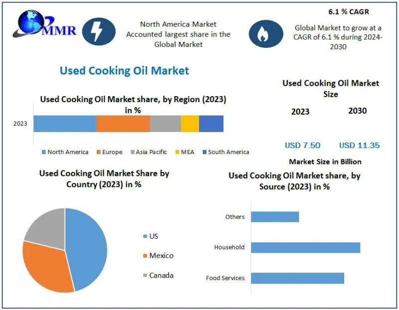
Used Cooking Oil Market Insights - Size, CAGR, Key Drivers, and Future Prospects …
Used Cooking Oil Market was valued at USD 7.50 Bn in 2023 and is expected to reach USD 11.35 Bn by 2030, at a CAGR of 6.1 % during the forecast period.
Used Cooking Oil Market Overview:
The Used Cooking Oil market is experiencing robust growth globally, driven by increasing awareness of sustainable practices and the rising adoption of biofuel production. Used cooking oil, primarily sourced from households, restaurants, and food processing…
More Releases for Imagery
OnGeo Intelligence Offers Free Satellite Imagery
OnGeo Intelligence allowing users to access free Satellite Imagery, delivering 10-meter resolution images enhanced to 2.5 meters for global locations. The service also provides high-resolution imagery to 0.3 metres - paid option. Breaking down barriers to advanced geospatial data access.
How it Works?
OnGeo Intelligence simplifies access to satellite imagery through its user-friendly platform. Users select a location and time range, and the system retrieves cloud-free images from a vast archive.…
Satellite Imagery for Precision Farming Market Utilizing Satellite Imagery for P …
The Report on "Satellite Imagery for Precision Farming Market" provides Key Benefits, Market Overview, Regional Analysis, Market Segmentation, Future Trends Upto 2030 by Infinitybusinessinsights.com. The report will assist reader with better understanding and decision making.
Market Growth of Satellite Imagery for Precision Farming Market: The Satellite Imagery for Precision Farming market is experiencing robust growth, driven by trends in high-resolution satellite imaging, AI-driven crop analysis, and the demand for sustainable agriculture…
colossis.io Revolutionizes Travel Marketing with AI-Enhanced Imagery
ALBUQUERQUE, NM, UNITED STATES, April 21, 2023
colossis.io, a leading provider of AI-enhanced travel imagery, is transforming the travel marketing industry with its cutting-edge technology. By leveraging the power of AI, colossis.io is able to elevate hotel and Airbnb photos to new heights, leaving customers in awe.
To take advantage of colossis.io's technology, all you need to do is upload your source imagery and let the AI work its magic. In just…
High-Resolution Multispectral Satellite Imagery Solutions | TELEPIX
TELEPIX provides high-resolution multispectral satellite imagery solutions to the military, intelligence, coast guard, and environment monitoring sectors. TelePIX develops these more cost-effectively than any other company by using lean procedures while maintaining quality and performance.
TelePIX High Resolution Satellite Images Product
MACC (Multi-Aperture Computational Camera)
Super-high resolution reconnaissance micro-satellite based on multi-camera synthetic aperture imaging
Captured images at LEO consists of WFOV(x1) using central camera module and NFOV(x3) using flat cameras with different LOS
MicroSat…
Outstanding Multispectral Satellite Imagery Solution | TELEPIX
TELEPIX provides outstanding multispectral satellite imagery solution in Korea. It offers a next-generation UHR (ultra-high resolution) multispectral EO/IR payload for government, military, intelligence, and space agencies.
TelePIX Multispectral Satellite Imagery
Multispectral satellites are the most affordable way to monitor any location on the planet. They beyond monitoring locations and capturing beautiful images because there is a need for actionable data to make more accurate decisions faster.
The benefits of Multispectral Imagery
Multispectral imagers are…
KOMPSAT Satellite Imagery Products | SI Imaging Services
SI Imaging Services contributes to the earth observation industry by providing very high performance remote sensing KOMPSAT satellite imagery products.
SI Imaging Services (SIIS) is a worldwide marketing and sales representative of the KOMPSAT series (KOMPSAT-3, KOMPSAT-3A and KOMPSAT-5). SIIS contributes Remote Sensing and Earth Observation industries by providing very high resolution optical and SAR images through over 160 sales partners worldwide. Customers from industries as well as government are using…
